-40%
HIDDEN TREASURE GOLD MINES #1 AND #2 , GOLD MINING CLAIMS, MARIPOSA COUNTY, CA
$ 2587.19
- Description
- Size Guide
Description
Hidden Treasure Gold Mines #1 and #2 , Gold Mining ClaimS, Mariposa County, CA (2)Item Description
Gold-Rich Ore taken out of one of the many Gold-bearing veins in Hidden Treasure #2
GENERAL CLAIM DESCRIPTION
Meeting of the Mines is proud to offer The
"Hidden Treasure Gold Mines #1 and #2
".
This is truly a mining oasis, private and secluded with lots of privacy, just off
Highway 49 - "The Golden Chain Highway."
Peace, serenity, and most importantly gold awaits. This is truly a fantastic opportunity to own two gold producing mining claims, that
have been virtually untouched for years and are ripe and ready for a beginner or seasoned Gold Miner.
The Hidden Treasure Gold Mines have yet to be mined to their true Gold yielding potential! Four wheel drive only.
What Gold Nuggets could be trapped under those massive boulders? (Sierra Blaster time!)
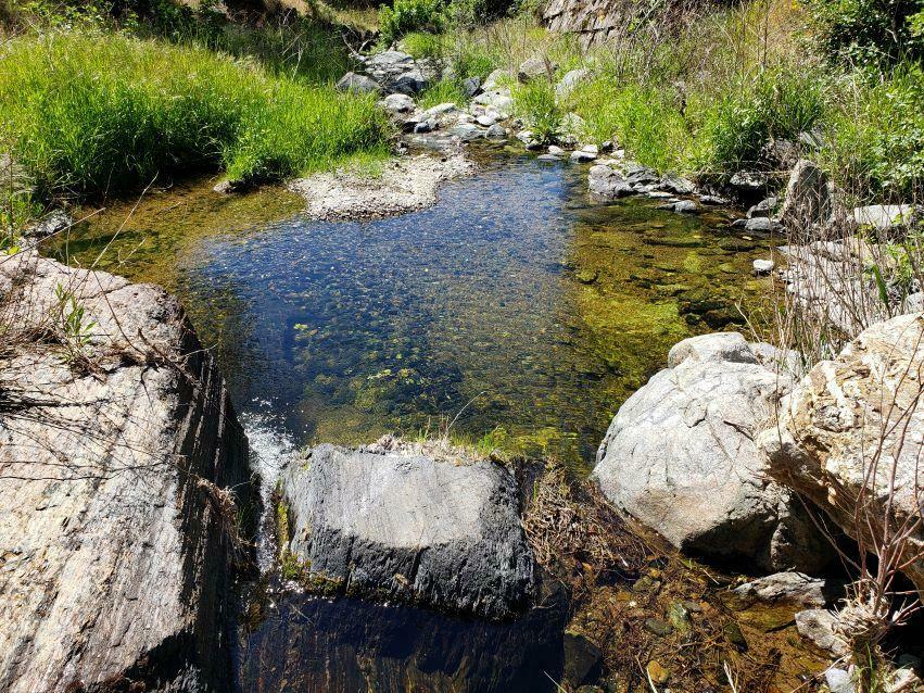
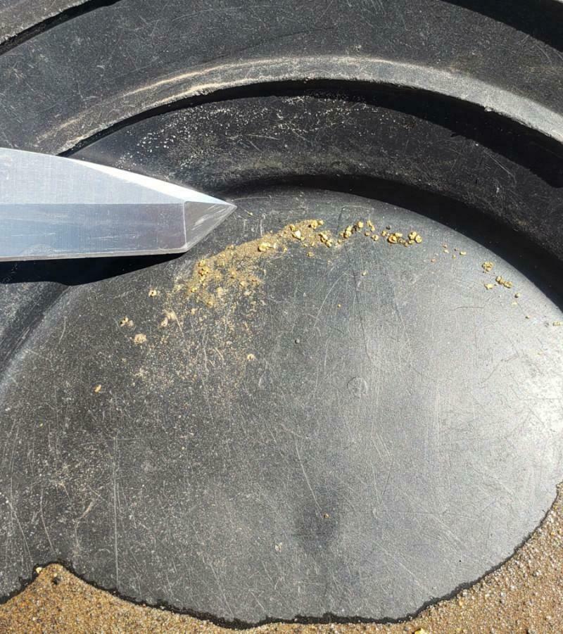
Taken up as lode claims for all of the gold-bearing quartz veins scattered about the claims, 3 natural springs supply plenty of water for your mining needs, see topo map below and the pictures above. Even in the last 2 drought filled summers we have had, pictures taken a few weeks ago showed water was still running. I imagine that during a normal rain year, these springs would run year around like small creeks. Approximately 15 Hardrock Gold Mines feed these placer-rich springs and Scotch Gulch with Gold. Crushing some hand-picked gold-bearing ore produced some promising results. See photo above.
You can tell from the old Timber Sets the Hidden Treasue #2 has not been Mined in an awful long time!
The
Hidden Treasure Gold Mines
are located in a Mining District that is known for having places where
high-grade ore is abundant
.
This dynamic screams to the potential for an individual or individuals using new age methods and technology to profit from this fantastic opportunity! This is an excellent spot for a small mining operation to work at a high profit from high grading the underground deposits or simply used as a piggy bank for some small miners equipped with a metal detector, cordless drill, cordless rotary hammer, Sierra Blaster kit, rock crusher, and Gold Hog Sluice chasing pocket gold. One good Gold specimen could be worth thousands. Not to mention at the Southwest corner of Hidden Treasure #1 is a nice place to set up a dredge at an old dam the old timers used to catch and divert water for their mining needs. (See photo above with waterfall)
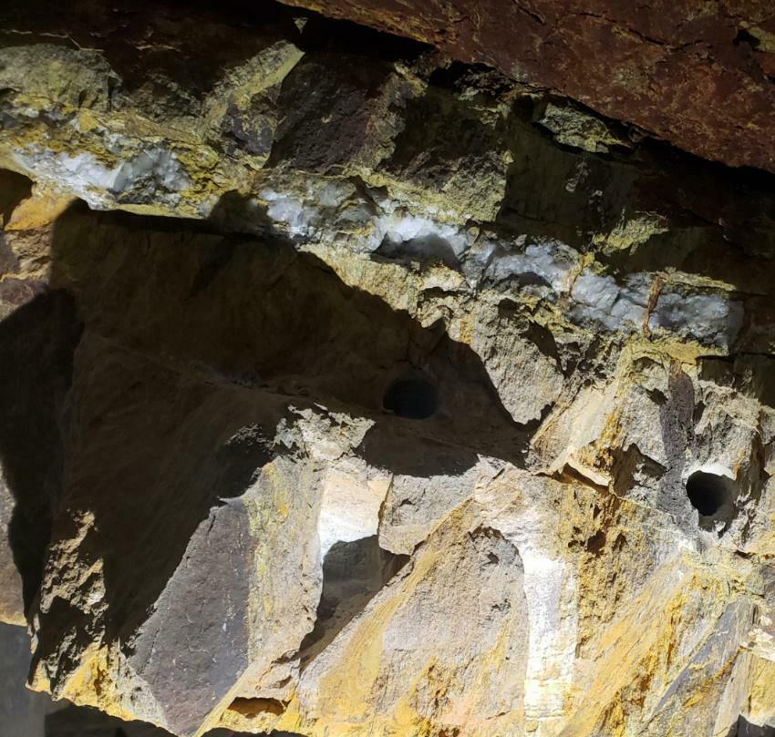
The adit entrence of Hidden Treasure #2 will need to be cleaned out at some point, but there is a big enough opening to be able to get into the mine. There is a metal mine door that was probobly used at some point along time ago but will need to have the area cleaned out before it can be used again. (The photos above show what I am talking about). Once in the Mine, it opens up into a large room, with smaller tunnels that branch off this room, with stoping and inclined digs. There is draft that comes through, so the main stope has to have an air vent higher up the hill. I did not go looking for this due to the heat of the day. I tried to show the veins they were chasing as good as I could in the photos above. They are mostly smaller gold-bearing veins that are mostly flat to 45 degrees. Some have higher degree angles which intersect with the smaller veins. The smaller tailing piles did show wider veins, so I am assumung up the hill the veins were wider.
Sufficient water for milling purposes can obtained from the springs when the water is running. Pictures were taken a few weeks ago and you can see the water flow at that time. During a normal rain year, I would assume water would be plentiful.
The dirt road you turn off of Highway 49 is very much a 4 wheel drive or some mountain terrain vehicle only. Let me repeat 4 wheel drive only. I have showed the steepness and ruts in the roads in photos above. 2 wheel drive will get you stuck and you will not be able to get to the claims without walking. There is places on the claim to tent camp, but getting some type of smaller 5th wheel down to the mines would be a major under taking. There are 2 RV parks within 15 miles of the claims.
The Hidden Treasure Gold Mines
are
located in a very rich mining district in the Sierra Nevada east gold belt, just off Highway 49. The chances of finding pocket gold are phenomenal and with gold prices sky-rocketing the The Hidden Treasure
Gold Mines
are prime for a gold-finding exploration.
So, whether you're a part-time prospector, full time gold miner, or dedicated metal detectorist, there has never been a better time to get involved in the modern-day Gold Rush! Not only is gold mining a hobby and or a full-time job that can pay you back, it's an activity the entire family can enjoy together in the great outdoors.
Perhaps one of the best benefits of gold prospecting, gold mining, and or metal detecting is that with the price of gold today, you don't have to find much to completely pay for your claim and equipment-- and the rest is pure profit!
These Gold Mines will give you lots of opportunity for finding big time gold. Here's your chance to own 2 Gold Mines in a very rich mining district, which will bring years of joy and gold to your family and will always have
tremendous resale value
.
Mining claims are mineral rights to Government land and the rights to extract precious metals. They are considered real property and can be bought, sold, leased, willed, transferred and etc.
Check out August 2020 and November 2019 back issue of ICMJ's Prospecting and Mining Journal, Nov. 2019 is us on the cover with a feature on our Hard Rock operation and August 2020 is a fantastic follow up on our progress! Photo of magazines below.
HIGHLIGHTS AND KEY POINTS ALONG THE ROUTE
Like mementos on a charm bracelet, the jewels of the 49er Gold Rush are linked by the Golden Chain Highway. Some of those "
charms
" include:
The
Empire Mine State Historic Park
in Grass Valley which was the richest hard-rock mine in California during its mining history of 106 years (1850-1956). From 1850 to its closing in 1956, it produced 5.8 million ounces of gold. These 5.8 million ounces of gold would fill a box 7 feet on each side. It is estimated that this represented only 20% of the available gold...80% remains.
Coloma is the site where the cry , “mettle…that looks like goald”, was shouted out in 1848, sparking the Gold Rush. It is home of the
Marshall Gold Discovery State Historic Park
. Exhibits in the Gold Discovery Museum at the Marshall Gold Discovery State Historic Park tell the story of John Sutter and James Marshall, and how drastically the simple act of noticing a small fleck of gold would alter the lives of hundreds of thousands of people from that day to the present.
The
Argonaut
and
Kennedy Mines
in Jackson were two of the highest-yielding gold mines in the state. Prospected in 1860, reorganized in 1886 and continuously run until 1942, the Kennedy Gold Mine produced approximately ,280,000 in gold according to the California Department of Conservation.
Angels Camp is situated in one of the richest quartz mining sections of the Mother Lode and is the home of the story of "The
Celebrated Jumping Frog of Calaveras County
", written by Mark Twain. The
Angels Camp Museum
is situated directly on top of the main Mother Lode gold vein and contains one of the largest, most comprehensive and diverse collections of artifacts in the Mother Lode and gold country areas in the Sierra Nevada region.
Chili Gulch
in Calaveras County is a five-mile gulch that was the richest placer mining section in Calaveras County. Its was named by the Chileans who worked it in 1848 and 1849. The largest known quartz crystals were recovered from a mine on the south side of Chili gulch.
Columbia State Historic Park
is the best preserved of the California Gold Rush towns, seemingly frozen in time. It offers a unique blend of museums, displays, town tours, and live theater plays.
Near the end of Highway 49 and just 20 Miles South of the Hidden Treasure #1 and #2
, in
Mariposa
, is a
beautiful jewel to be found at the California Mining and Mineral Museum
. Once there, you will be amazed at the "
Fricot Nugget
", a rare and beautiful specimen of crystallized gold discovered in the American River in 1864. This spectacular 13.8 pound specimen is the largest remaining intact mass of crystalline gold from 19th century California."
And yes, there still is gold in "them thar hills!"
Bagby-Mariposa-Mount Bullion-Whitlock Mining District, Mariposa County, California
Location, History, Geology, Ore Deposits, Mines
This district is comprised of several former smaller districts:
Bagby District:
Location:
This district is in western Mariposa County in the vicinity of the towns of Bagby and Bear Valley. It is in the Mother Lode gold belt. History. The streams were placer-mined early in the gold rush, and the Pine Tree and Josephine veins were discovered in 1849. Part of the area was on the Las Mariposa Spanish land grant of General John C. Fremont. Bagby was first known as Benton Mills, named by Fremont for Senator Thomas Hart Benton, his father-in-law. It was renamed in the 1890s for A. Bagby, a hotel owner. The town was a stop on the Yosemite Valley Railroad, which once extended up the Merced River canyon to Yosemite National Park. Gold mining activitv' continued until around 1875. There was mining in the district again in the early 1900s. The Pine Tree-Josephine mine was worked on a major scale from 1933 to 1944, and the Red Bank mine has been active in recent years. Part of the area, including the old town of Bagby, was inundated by the Exchequer Reservoir in 1967.
Geology:
In this district the Another Lode gold belt is .about 1 Yi miles wide. It is underlain by northwest-striking beds of slate, phyllite, and metasandstone of the Mariposa Formation (Upper Jurassic), with greenstone and green schist both to the west and southeast (see fig. 18, page 95). A belt of serpentine extends northwest through the central portion of the district and is structurally important in relation to some of the gold-bearing veins. Ore deposits. There are several northwest-trending vein systems that consist of quartz veins and stringers with brecciated slate, schist, and associated bodies of pritic ankerite and mariposite-quartz rock. These vein systems are often scores of feet in thickness. The ore contains free gold, pyrite, and arsenopyrite with small amounts of chalcopyrite, galena, millerite, sphalerite, and niccolite. Milling ore averaged 1/7 to 1/2 ounce of gold per ton. In places high-grade ore is abundant. The ore shoots had stoping lengths of up to 600 feet, and the veins were mined to an inclined depth of 1500 feet.
Mines:
Dolman, French (6,000), Jumper, Juniper, Live Oak, Mexican I (,000), Oso (,000), Pine Tree-Josephine ( million), Queen Specimen, Red Bank (0,000), Specimen.
Mariposa District:
History:
This district is in the vicinity of the town of Mariposa at the southeast end of the Mother Lode gold belt. The Mariposa mine was reported to have been discovered in 1849 by Kit Carson, and the first stamp mill in California was installed there that same year. Much of this district was part of the Las Mariposas Grant of General John C. Fremont. The old courthouse in Mariposa erected in 1854 is the oldest continuously used courthouse in California. The mines were worked until the early 1900s and again during the 1930s. The Mariposa mine has been prospected in recent years.
Geology and Ore Deposits:
The district is underlain by northwest-trending belts of slate of the Mariposa Formation (Upper Jurassic), serpentine, and greenstone. There are several massive quartz veins in slate or greenstone. The ore contains free gold, pyrite, and arsenopyrite, which often is associated with highgrade ore. The Mariposa mine has been developed to an inclined depth of 1500 feet.
Mines:
Evans II, Kane, Mariposa (,395,000),
Stockton Creek, Stockton Creek Tunnel.
Mount Bullion District:
Located in westcentral Mariposa County about seven miles northwest of Mariposa. The district is in the southern end of the Mother Lode gold belt and extends northwest towards Bagby and Bear Valley (fig. 18). It includes the Agua Fria and Mount Ophir areas.
History:
This region was first placer-mined in 1848, many of the miners having been of Spanish descent. Agua Fria Creek and other streams were highly productive (Agua fria means cold water in Spanish). Lode gold-mining began shortly afterward. Much of this district is in the Las Mariposa land grant, which originally belonged to General John C. Fremont. The mines in this grant were not located and surveyed in the same fashion as those on public lands, and to this day the land plats within this grant are difficult to coordinate with established survey lines. The grant later underwent lengthy litigation, and Fremont eventually went bankrupt. He named nearby Mount Bullion for his father-in-law. Senator Thomas Hart Benton, who was sometimes known as "Old Bullion." At Mount Ophir, which is now a ghost town, are the ruins of an early-day mint. From 1849 until 1854 private coinage subject to federal inspection was authorized in California. It is believed that some of the now extremely rare and valuable octagonal fifty-dollar gold slugs were minted here from locally mined gold. Gold mining in the district continued fairly steadily from the 1850s through the 1870s. There was considerable activity from around 1900 to 1920 when the Princeton and other mines were worked. Some mining was done in the 1930s and early 1940s, and there have been a few intermittent small-scale operations since.
Geology:
As shown in figure 18, the gold mineralization is confined chiefly to a northwest-trending belt of slate, phyllite, and metasandstone of the Mariposa Formation (Upper Jurassic). Within this formation are two belts of pyrite-bearing metarhyolite that may have possible future economic significance. Greenstone of the Pefion Blanco Formation (Upper Jurassic) crops out to the east and west. Also present are thin bands of serpentine and numerous aplite dikes.
Ore Deposits:
Several north-northwest-striking systems of quartz veins occur principally in slate. The veins usually range from four to 10 feet in thickness, although there are some massive ones that are considerably thicker. The ore contains free gold and pyrite, which is abundant in places. Millng ore yielded from ¼ to ½ ounce of gold per ton, and considerable highgrade ore was recovered close to the surface. Some of the ore shoots were extensive; several in the Princeton mine had stoping lengths of more than 500 feet. The greatest depth of development is 1,600 feet on the incline. A number of extensive vein systems have not been thoroughly explored. Also, there are several extensive 1970 deposits of pyritic metarhyolite in the Mariposa Formation that in places contain gold. These bodies are several miles long and 60 or more feet thick.
Mines:
Greens Gulch (9,000+), King Midas, Louis, Mt. Ophir (0,000 to 0,000), Mountain View I, Nellie Kahoe, Ortega, Princeton 1 $ 5 million), Sorrel.
Whitlock District:
Location:
The Whitlock district is in west-central Mariposa County five miles north of the town of Mariposa. The district is east of the Mother Lode gold belt and includes the Colorado, Sherlock Creek, and Whiskey Flat areas. The area was placer-mined soon after the beginning of the gold rush, and lode mining began shortly afterward. A number of mines were active here during the 1930s, and a few, such as the Diltz and Schroeder mines, have been intermittently prospected in recent years.
Geology:
Greenstone and green schist underlie much of the district, with some slate, phyllite, and mica schist in the north portion. Granitic intrusives and serpentine are to the south. There is an appreciable number of diorite, quartz-diorite, and aplite dikes that commonly are associated with the gold-quartz veins. A northwest-trending fault extends along the west side of the district (see fig. 18).
Ore Deposits:
Numerous north- and northweststriking quartz veins contain small but rich ore shoots. The veins usually are one to five feet thick, and a number dip at low angles. The veins have a tendency to roll or bend, and it is in these bends or rolls that the high-grade pockets often occur. Much specimen ore has been produced in the district; in 1932 the Diltz mine yielded 52- and 40-pound masses of gold and quartz. The greatest depth of development is about 900 feet.
Mines:
Buffalo, Champion, Colorado (,000), Diltz (0,000 to million), Geary, Golden Key (4,000), King Solomon, Landrum, Nutmeg (0,000+), Our Chance, Permit, Schroeder (0,000 to 0,000), Spread Eagle (5,000), and the Whitlock (0,000).
CLAIM PARTICULARS
The Hidden Treasure #1 and Hidden Treasure #2
HT #1 is in Section 25, Township 3S, Range 16E, Mount Diablo Meridian
CA105248171
HT #2 is in Section 25 and 36, Township 3S, Range 16E, Mount Diablo Meridian
CA105248172
2 Lode Claims
*GPS COORDINATES AVALIABLE UPON REQUEST
Driving Directions
From Coulterville, take Hwy 49 towards Mariposa for 7.8 miles. Turn right onto dirt road pictured below.
Please note pictures below, if you drive past the rock shown below you have gone too far.
Continue for approx. 0.36 of a mile (1910 feet), at this point you will have arrived at the bottom portion of Hidden Treasure 2.
TURN RIGHT, IF YOU GO PAST THE ROCK IN THE PICTURE ABOVE, THAN YOU HAVE GONE TOO FAR. CONTINUE TO FOLLOW THE ROAD AS SHOWN BELOW.
Area Recreation and Nearby Towns
The claim is located approx 8 miles from Historic Coulterville, 18.9 miles from Historic Mariposa, and
Yosemite Valley
floor is approx. 39.2 miles. There is area to camp on the claim, but four-wheel drive is required, so taking a 5th wheel to the claim is not realistic. Looking for a RV Park? Yosemite Westlake Campground & RV Park located in Greeley Hill is 16 miles away.
Feedback:
If there are any problems please send me an email and I will do my best to resolve them.
If you have any questions, please email me. You are dealing with a real miner/prospector here.
Payment Details
Payment Information
Accepted methods of payment: Personal/Business checks, direct deposits or wire transfer, cashier's check and money orders. PayPal does not allow payment for real estate or land purchases and mining claims are considered real estate, so we are unable to accept payment through PayPal. No returns or exchanges, contact me with questions.
Transfer of Ownership
Once payment is received and clears, a deed will be filled out with your name or names and notarized transferring ownership to the new owner. Either you or I can mail (a lot of time I will hand deliver to the appropriate County and BLM) it to the appropriate County recording office and BLM, but I would rather do it so I know it’s done correctly, but of course that is your call. I will pay all transfer fees. If you purchase this claim or claims we will be sending you a packet with all the appropriate claim paperwork after the payment clears.
Additional Information
Meeting of the Mines takes great pride in finding claims for the serious miner and the hobbyist miner.
We do thorough research to ensure that we sell only open claims. Our claims never overlap a LOAD or PLACER claim,
we never top file!
The photos below show our current hardrock mining operation and equipment used.
Track Page Views With
Auctiva's FREE Counter
